
Aerial & Property Models
Aerial 3D Models of Your Whole Property
We fly your property with an enterprise drone and build an interactive 3D model of the buildings and grounds, plus a high-resolution overhead map. Paired with your interior tours, visitors can see how everything fits together.
FAA Part 107 certified aerial capture
Two Views of the Outside
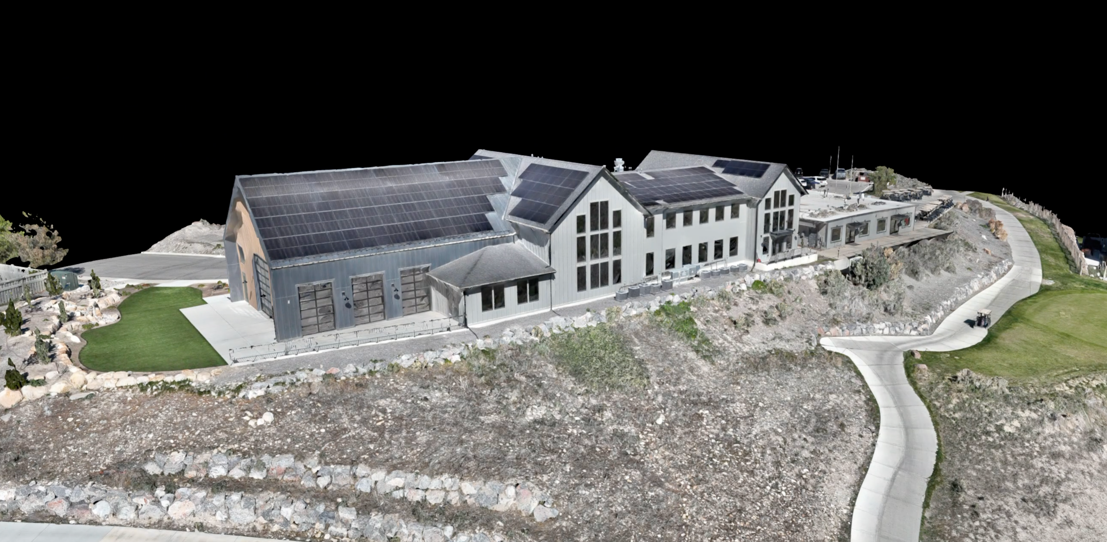
Interactive aerial 3D model
A photogrammetry model built from hundreds of overlapping drone photos. Visitors can rotate, zoom, and look at the buildings, landscaping, and grounds from any angle, right in the browser. No app to install.
High-resolution overhead map
A single, map-corrected overhead image of the whole property, stitched from the same flight. It's sharper and more current than the satellite view most people see online, and it's useful for planning, wayfinding, and print.
Show the Grounds, Not Just the Rooms
See the whole campus
Interior tours show the rooms. An aerial model shows the lawns, courtyards, outbuildings, and views that connect them.
Help guests and planners find their way
Where's the ceremony lawn relative to the parking? How far is the cabin from the lodge? An overhead view answers it in seconds.
Plan outdoor events
Give planners and vendors a real base for tents, staging, parking, and load-in routes, before anyone sets foot on site.
Connect outside and inside
Link the aerial model to your interior 3D tours so visitors can move from the grounds into the building and back.
What's Included
- An interactive aerial 3D model of the buildings and grounds in scope, with a shareable link and embed code
- A high-resolution overhead map (orthomosaic) of the property
- Links between the aerial model and your interior 3D tours (when we capture both)
- Pre-flight airspace check and scheduling around your events
The Venue at the Ranches: Inside and Out
On the left, the interior 3D tour of the event spaces. On the right, an aerial photogrammetry model of the entire exterior, from the building footprint to the surrounding landscape.
Interior 3D tour
Aerial 3D model
Also see: Commercial Warehouse, a photogrammetry 3D model of a commercial facility
How It Works
- 1
Scope call
We look at your property on a map together, agree on the area to cover, and check airspace.
- 2
Flight
FAA Part 107 certified aerial capture, scheduled around your events and the weather.
- 3
Build
We process the photos into the 3D model and overhead map and link them to any interior tours.
- 4
Delivery
You get links, embed code, and files. Turnaround is 1-2 weeks.
Questions About Aerial Models
Do we need to close the property?
No. We schedule the flight around your calendar. People and vehicles on the ground will show up in the capture, so quieter times give cleaner results.
Can you fly anywhere?
Most properties, yes. Some are near airports or in controlled or restricted airspace, which can require FAA authorization or limit where we can fly. We check during the scope call and tell you up front.
How does this connect to our interior tours?
When we capture both, we link them so visitors can move between the aerial model and the interior tour. They can also sit side by side on your website.
How accurate is the overhead map?
It's built for visualization and planning: seeing layouts, measuring approximate distances and areas, and planning events. It isn't a land survey. If you need survey-grade accuracy or legal boundaries, work with a licensed surveyor.
Is an aerial model right for our property?
It depends on your grounds and what you want visitors to understand. Tell us about your property and we'll give you a straight answer.
Thinking About an Aerial Model?
Every property is different. Tell us about yours and we'll tell you honestly whether an aerial model is a good fit and what it would involve.